|
BOUNDARY CONFLICTS:
A TEACHING STRATEGY
|
Overview
Main Ideas
The following lesson reveals how the
absolute and relative locations of Illinois
political boundaries have changed over
time. Students will identify and analyze conflicts that have occurred along the external
boundary of Illinois. Cooperative learning
will be implemented as students engage in
a conflict resolution activity.
Connection with the Curriculum
"Location" and the activities contained in
the accompanying lesson plan are appropriate for use in social studies classes. We
especially recommend their use in the study
of geography, United States and Illinois history, political science, and economics.
Teaching Level
Grades 8-12
Materials for Each Student
A copy of the content portion of this
article.
A copy of each Illinois map accompanying this article.
An atlas or road map depicting
Illinois and neighboring states.
Handouts 1 through 4.
Objectives for Each Student
Determine the absolute location of the extremes of
Illinois.
Recognize the changing
relative location of Illinois
boundaries.
Understand how historical
events have contributed to
the present size and shape
of Illinois.
Understand and analyze
how Illinois' relative location
to bordering states has
resulted in conflicts with
them over time.
Develop a historical perspective to facilitate preparation of a proposal that
might help resolve present
conflict and prevent future
wrangling.
5
SUGGESTIONS FOR
TEACHING THE LESSON
|
Opening the Lesson
Distribute Handout 1 Size and
Boundaries of Illinois and instruct
students to answer the questions by
observing the map that accompanies
this article and an atlas.
Distribute Handout 2 Conflict
around the State and instruct students to complete it by referring to the
content portion of this article. Discuss
student responses. Answers will vary.
Developing the Lesson
Beginning the Group Activity
Explain to students that they will be representing Illinois or one of six bordering
states. The purpose of this group activity is
for students to recognize past and present
conflict and develop arguments on behalf of
their assigned state as well as a specific
proposal that could help prevent future conflict. These proposals will go before a panel
of seven students consisting of a representative from each state.
Establish groups by dividing students
into seven teams. Each group will represent a particular state.
Distribute Handout 3 State
Scenarios which contains information that will be helpful for students in
recognizing conflict and in preparing
their proposals. All groups receive all
scenarios.
Distribute Handout 4 KIMWIMI
(Kentucky, Indiana, Michigan,
Wisconsin, Iowa, Missouri, Illinois)
Convention. Please note that the
Illinois representatives will have to
develop and direct their comments in a
general fashion toward all the bordering states.
Students work on proposals, referring
to content part of article.
Presentation of Proposals
Instruct each group to select one student to represent their state on the
Panel of Seven. This student will present his or her group's proposal to the
panel. It would be appropriate for the
Illinois representative to chair the proceedings. The Illinois representative
should begin the proceedings by providing a general overview of the
KIMWIMI Convention and then call for
each state to present its proposal.
Deliberation by Panel of Seven
After hearing the proposals, the panel
will deliberate in open forum, caucus
privately, and announce recommendations.
Class members not serving on the
panel should listen to proposals and
take notes during the open forum.
These individuals should return to their
state groups during the panel caucus,
discuss panel deliberations, predict
panel recommendations, and be prepared to react to the panel of seven
recommendation.
Concluding the Lesson
Announcement of Panel Recommendations.
The panel chair presents the recommendations to the class.
Engagement of Class in Discussion.
The class has an opportunity to question and challenge panel recommendations.
The class engages in general discussion about the nature of conflict
among Illinois and bordering states by
focusing on geographical and historical perspectives.
Extending the Lesson
Identify examples of local boundary
conflicts, e.g., school districts, county
boundaries, townships, farm property,
neighbors in town, etc. Gather information
about the origin of the conflict by interviewing appropriate individuals, visiting a library
or other sources. This information could be
shared with class members.
Assessing Student Learning
Instruct students to develop a written
response to the following by drawing upon
geographical and historical information
acquired from the location activity.
Observe the map(s) of Illinois and
speculate at least three locations for
potential future conflict between Illinois
and its neighboring states.
Offer an explanation for the occurrence of conflict at your indicated
sites. What specific measures should
be taken to prevent or minimize future
conflict between Illinois and bordering
states?
6

Please answer the following by referring to "Location," an Illinois map, and an atlas. Identify
in 1-4 the latitude and longitude (to the nearest minute) of the four extremes (corners) of the
state.
- Northeast extreme: Latitude_________. Longitude_________.
- Northwest extreme: Latitude _________. Longitude ________.
- Southwest extreme: Latitude _________. Longitude ________.
- Southeast extreme: Latitude _________. Longitude _________.
- Determine the length of the state (from northernmost point to southernmost point)
in miles.
Answer: ______________________________________ miles.
- Go due EAST from your hometown or school the number of miles in question 5 and indi-
cate the state and nearest urban place (city, town, or village) of your new location. Those
of you living in the northern part of Illinois might have to improvise because your new
location could be in water or even in Canada.
Answer: ______________________________________
- Take the number of miles from question 5 and go due WEST from your town or school.
Indicate the state and nearest urban place.
Answer: ______________________________________
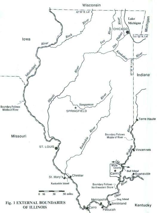
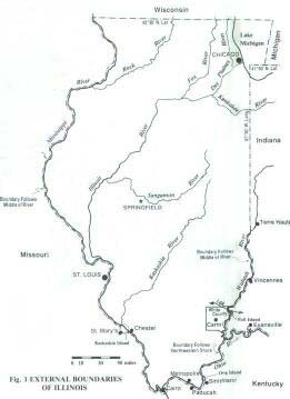
- Identify the water boundaries of Illinois.
A. _____________________. C. _________________.
B. ______________________. D. _________________.
- Identify the states that border Illinois.
A. _____________________. D. _________________.
B. ______________________. E. _________________.
C. _____________________. F. _________________.
7
Answer the following by referring to the examples in "Location."
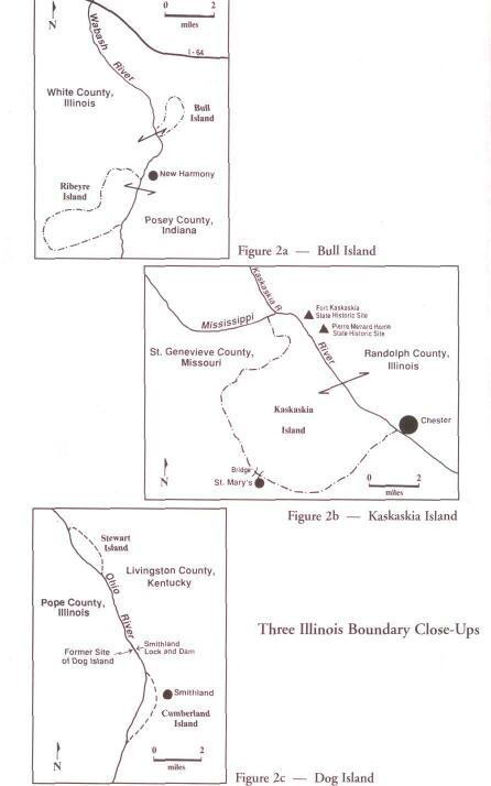
- How did Bull Island's location influence the occurrence of a major rock festival in 1972?
- Suppose Indiana had assessed Illinois for the use of Indiana authorities to control the flow
of traffic into Bull Island. Should Illinois pay Indiana for these services? Provide reasons for
your response.
- Identify ways in which Illinois would be different today if Nathaniel Pope had not influenced Congress to alter the original northern border.
- Should the state of Illinois feel obligated to reimburse Wisconsin for the territory
Wisconsin lost during the 1800s to Illinois? Provide reasons.
- How does Kaskaskia Island's relative location result in conflict between Missouri and
Illinois?
- Would it be reasonable for the town of St. Mary's, Missouri, to establish a toll on vehicles
traveling to and from Kaskaskia Island? Explain please.
- How does the location of Kentucky's boundary along the Ohio River result in conflict with
Illinois, Indiana, and Ohio?
- Should Illinois continue to pursue legal and other means to alter its boundary with
Kentucky? Explain your answer.
8

At the end of each state scenario below are
1993 figures for (A) motor fuel tax per gallon
of gasoline and (B) state cigarette tax per
pack of twenty. Comparable Illinois figures
are (A) 19 cents and (B) 44 cents.
Wisconsin
The Badger State is still fuming (some
believe) about losing a large area to Illinois
in the 1818 "ripoff." Wisconsin decided to
keep its drinking age of 18 after Illinois
raised its limit to 21. Wisconsin once
passed a law that gave its residents first
pick of camping sites because Illinois visitors were taking all the prime spots. Illinois
sued Wisconsin years ago, claiming the
Dairy State was dumping raw sewage into
the waters that flowed to Illinois. Wisconsin
countered with a lawsuit alleging Chicago
allowed air pollution to drift northward into
Wisconsin. (A) 2.2 cents. (B) 38 cents.
Missouri
Some Missourians still contend that
Kaskaskia Island belongs to the Show-me
State. Thousands of tax dollars that could
go to Missouri are collected each year by
the Land of Lincoln. Illinois River pollutants
affect the Mississippi River and the water
supply of St. Louis. Illinois is upset about
the dollars that Missouri reaps from Illinois
residents crossing the border to purchase
fireworks they cannot buy in Illinois.
Downwind from St. Louis, Metro East's
(East St. Louis, Edwardsville, and other
Illinois communities) location puts it in the
path of air pollution drifting eastward. (A)13
cents. (B) 13 cents.
|
Iowa
Riverboat gambling poses a major conflict
between Iowa and Illinois. Fierce competition has resulted in the recent closing of
some riverboat gambling facilities on the
Iowa side. Much money is at stake. Iowa
has lured Illinois residents across the
Mississippi to gamble on dog races, something Illinoisans cannot do at home. State of
Illinois officials would rather see Illinois' dollars stay east of the river. (A) 20 cents. (B)
36 cents.
Kentucky
Illinois residents have had to purchase
Kentucky fishing and boating licenses to
use any part of the Ohio River. Kentucky
made threats toward a floating casino based
in Illinois in 1993 claiming it was going to be
operating in Kentucky territory, where riverboat gambling does not exist. Kentucky collects tax dollars from Illinois residents who travel across the Ohio to purchase cheaper
cigarettes. (A) 15 cents. (B) 3 cents.
Indiana
Officials in Illinois express concern over the
revenue lost to Indiana as Illinois motorists
go to the Hoosier State to purchase cheaper gasoline. Some Illinois residents buy
large quantities of cigarettes (which are
taxed at a much lower rate) in Indiana and
transport them to Illinois. One man brags
that he buys a year's supply and keeps
them frozen until ready to smoke them.
Trying to figure out the time in these two
states is also a problem. (A) 15 cents. (B)
15.5 cents
Michigan
Carried by the water current that
comes down the west side of Lake
Michigan past Chicago and turns
eastward across northern Indiana
toward Michigan's shores,
pollution from Illinois can
wind up on Michigan beaches
or in the drinking water. The
unmarked boundary between
Illinois and Michigan
can lead to jurisdictional problems in
boating accidents, airplane crashes, and
resource recovery (fish and minerals).
(A) 15 cents. (B) 25 cents.
9

Over the years, Illinois has experienced
considerable conflict with neighboring states
as a result of changing boundaries, changing interpretations of boundaries, and varying policies across the boundaries. Illinois officials have called the KIMWIMI (Kentucky,
Indiana, Michigan, Wisconsin, Iowa,
Missouri, Illinois) Convention to bring
together negotiators from Illinois and the
surrounding six states. Illinois officials have
expressed concern over past conflicts and
the loss of revenue that has occurred due to
some of these conflicts. The purpose of the
convention is to develop a joint proposal
that will put to rest past disputes and prevent future conflict between Illinois and its
neighbors. Your peers have recommended
you highly as a delegate from your state at
the KIMWIMI Convention. Good luck.
You will perform the following specific tasks.
- Identify previous conflict hot spots.
- Speculate about future conflict that might
result from existing relationships between
Illinois and neighbors over taxation, water
quality, and other issues.
- Develop a proposal that will help alleviate
present conflict and prevent the occurrence
of future conflict.
- Help prepare a presentation to a panel of
representatives (one from each state) during the convention. Focus your presentation
on an overview of past and present boundary conflicts involving Illinois and make recommendations to the Panel of Seven that
would minimize conflict between Illinois and
the states that border Illinois.
|
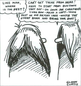
Fig. 3. One of a series of cartoons artist
Glenn Curtis prepared to accompany news
stories appearing around Labor Day 1972 in
the Mt. Vernon [Indiana] Democrat concerning the Erie Canal Soda Pop Festival.
Courtesy Mt. Vernon Democrat.
|
10
11
Click Here to return to the Article
12
|