|
|
PLACE: TEACHING STRATEGIES
|
Overview
Main Ideas
Illinois is a state that is mainly level land
with temperate cropland replacing mostly
native prairie. Illinois has abundant natural
resources, including outstanding soil, abundant and well-distributed fresh water
resources, and much mineral wealth. Illinois
is a prosperous, heavily populated state
with a variety of cultural, racial, and religious groups from all over the world.
Connection with the Curriculum
These lessons could be taught in geography, government, history, sociology, economics, or general social studies classes.
Teaching Level
Grades 7-10.
Materials for Each Student
a physical and political map of Illinois
colored pencils
a pencil
Objectives for Each Student
Lesson 1 -
The Physical Geography of Illinois.
Locate and describe the four major
physical regions of Illinois: the Great
Lakes plains, the glacial till plains, the
gulf coastal plains, and the driftless
sections.
Name and locate the mineral
resources of Illinois coal, petroleum, sand, gravel, clay, limestone,
lead, zinc, and fluorite.
Name, describe, and locate the two
climates of Illinois: humid continental
warm summer and humid subtropical.
Learn that Illinois has abundant fresh
water resources in several forms:
lakes, streams, and ground water.
Learn the names and locations of the
three major river systems of Illinois:
the Mississippi, the Illinois, and the
Ohio, as well as the names and locations of the major tributaries of these
rivers.
Learn the names and locations of the
major reservoirs in the state: Lake
Clinton, Lake Shelbyville, Lake
Carlyle, Rend Lake, Crab Orchard
Lake, and Lake of Egypt.
Learn that the natural vegetation of
Illinois is 90% prairie and 10% forest.
16
Each student should know that most
of the forested area was concentrated
in southern Illinois, that the forests are
mixed deciduous ones, and that only
2% of the native prairies remain
because of Illinois' extensive farmland.
Gain awareness of the variety and
types of wildlife in Illinois.
Lesson 2 -
Cultural Geography of Illinois.
Learn the names, descriptions, and
general locations of the major Indian
tribes that once lived in Illinois.
Learn that there is a great variety of
those cultural groups that have moved
to Illinois. Students should know the
names of those cultural groups and
approximately when they came.
Learn the major agricultural products
of Illinois: corn, soybeans, hogs,
wheat, oats, hay, fruits, vegetables,
dairy and beef cattle, poultry, potatoes,
and sorghum.
Learn that agriculture provides a slight
portion (about 1%) of the state's annual income, that service businesses
provide most of the income produced
by the state (75%), and that manufacturing jobs provide the largest single
source of income (20%).
Learn basic statistical information
about Illinois such as length, width,
number of counties, ranking in land
area and population, and per cent of
urbanization.
Learn the names, locations, and general categories of the major cities of
Illinois. The five general categories are
major metropolitan areas, major urban
collar cities, mid-hinterland cities,
regional cities, and university cities.
SUGGESTIONS FOR
TEACHING THE LESSON
|
Opening the Lessons
Have students read the content
portion of the chapter "Place."
Assign the activities to the students.
Students can do one or both activities
in any order. Directions are provided
for each activity for the students to
read on their own or listen to the
teacher's explanation.
Make sure that students have the
materials needed to do each lesson.
Developing the Lessons
Allow students time to complete each
lesson. The lessons may be done individually, in small groups, or as a whole
class, whatever is most suitable for
your students.
Circulate through the room to check
their work and answer questions while
they work.
Concluding the Lessons
Grade or check the correct answers to
each activity.
Review and summarize for students
what they were to have learned.
Extending the Lessons
Students could plan one-week trips
throughout Illinois to see a variety of
places that interest them.
Students could predict future changes
in Illinois based upon what they have
learned about "place."
Assessing Student Learning
Give a test or quiz.
An alternative means of evaluation
would be to have students write a
report on Illinois using the information
they have learned. Students would be
provided with an outline or list of topics to be included in their report.
17
Student Name _______________ Period ____ Score ____ Grade ____
The Lithosphere - Physical Regions
Match each of the four physical regions of Illinois with
their definitions.
|
_ 1. Great Lakes Plains
_ 2. Glacial Till Plains
_ 3. The Gulf Coastal
_ 4. The Driftless Sections |
A. hilly places that glaciers
never covered
B. fertile plains formerly
covered by a lake
C. part of the enormous
Plains plains region stretching
to the Gulf of Mexico
D. flat, fertile plains formerly
covered by glaciers
|
Color each of the physical regions of Illinois the following colors on the physical features map of Illinois.
|
Great Lakes Plains
Glacial Till Plains
Gulf Coastal Plains
The Driftless Sections (4 of them)
|
- yellow
- brown
- light green
- dark green
|
Mineral Resources
Illinois has several mineral resources. Match the minerals of Illinois with their uses.
|
_ 1. coal
_ 2. oil
_ 3. sand, gravel, and clay
_ 4. limestone
_ 5. lead
_ 6. zinc
_ 7. fluorite
|
A. used in construction of
roads and buildings
B. used in batteries and to
galvanize steel
C. used to make aluminum,
steel, hydrofluoric acid,
lenses,and prisms
D. used to make fuels, lubricants, and plastics
E. used in batteries, gasoline, paints, and dyes
F. used in construction and
to produce steel
G. used as fuel to produce
electricity and as an
ingredient to make steel
|
Label the physical features map of Illinois as follows:
Circles label with a "C" for coal
Triangles mark with an "O" for oil
Squares mark with a "B" for building materials
Diamonds are already labeled with "Z" for zinc,
"L" for lead, and "F" for fluorite
The Atmosphere - Climates of Illinois
Trace the dashed line running across the southern
part of the state in red. It separates the two climates of
Illinois the humid continental warm summer climate and
the humid subtropical climate. Now write the name of each
climate next to its description below.
- __________________. This climate has four seasons, but temperatures are usually either cool,
warm, or hot. Precipitation is fairly high and there is not
much snow.
- __________________. This climate
has four seasons, moderate precipitation, and a big temperature range between winter and summer.
The Hydrosphere - Rivers, Lakes, and Reservoirs
Use an atlas and colored pencils to do the following
things on your Illinois Physical Map.
- Trace the Illinois River and all its main tributaries shown
on the map in green. Now label the Illinois River on the
map as well as each of the tributaries with their names.
- Trace the Mississippi River and its tributaries in blue,
and label all of them.
- Trace the Ohio River and all of its tributaries in orange,
and label all of them.
Lakes and Reservoirs
Besides Lake Michigan, Illinois has a few large, natural
lakes. Manmade lakes are called reservoirs. They are used
for flood control, electricity, recreation, and as fresh water
supplies in Illinois. Label the following lakes and reservoirs
on the map. They have all been drawn in for you.
|
Lake Michigan
Lake Clinton (reservoir)
Lake Shelbyville (reservoir)
Lake Carlyle (reservoir)
|
Rend Lake (reservoir)
Crab Orchard Lake (reservoir)
Lake of Egypt (reservoir)
|
The Biosphere - The Plants and Animals of Illinois
Fill in the missing letters to each term below which is
found in Illinois.
1. P _ a _ r _ e - the natural vegetation that once covered
90% of Illinois.
2. m_x_d d_c_d_o_s - the type of forests
most common to Illinois.
What are these wildlife found in Illinois?
|
Animals
3. _q_i_r_l
4. r_c_o_n
5. _p_o_s_m
6. r_b_i_
7. _o_
8. g_o_n_ h_g
9 . _u_k_a_
10. b_a_e_
|
Birds
11. _u_k
12. g_e_e
13. _h_a_a_t
14. q_a_l
15. _a_d_n_l
|
Fish
16. b_s_
17. _e_c_
18. b_u_g_l_
19. _r_p_i_
20. s_n_i_h
21._a_p
22. c_t_i_h
23. _i_e
|
18
Student Name _______________ Period ____ Score ____ Grade _____
The Indians of Illinois
Before there were Europeans and other ethnic groups
from all over the world in Illinois, there were the Indians.
Illinois is named after the Illiniwek Indians. The name
means "the men" or "superior men." French fur trappers
called them the Illinois. Although powerful, they were
defeated by other tribes, particularly the Iroquois. Very few
lived by 1800.
The Illiniwek Indians were actually several tribes that
had formed a confederation or alliance. They did this to
trade with each other and to protect each other from other
tribes. Some of these tribes were the Peoria, Kaskaskia,
Cahokia, Maroa, Tamaroa, Michigamea, and Moingwena.
All except the Moingwena are labeled on the map.
Write the word Illini in all capital letters on the map in
the general area where these tribes lived, and then lightly
color this part of the map one color. Have the color fade
away to nothing at the edges of the Illiniwek territory
because Indians did not often have specific boundaries for
their territory and because boundaries changed frequently
when tribes fought each other.
At various times between 1630 and 1800 many other
Indian tribes lived in Illinois. Here is a list of the major ones.
Label them on the map on the lines provided. The numbers
on the map match the numbers and names of the tribes
below.
- The Iroquois. They were a large and powerful eastern invader that sided with the British. The Illiniwek
were friends of the French. The Iroquois attacked
many other tribes and forced them to move to new
places.
- The Miami. They were pushed through northern
Illinois by the Iroquois, and some settled as far north
as southern Wisconsin.
- The Potawatomi. First they came from southern
Michigan and settled along the land near southern
Lake Michigan. Then they pushed into central Illinois
during the 1700s and fought the Illiniwek.
- The Sauk (or Sac). Pushed into Illinois by the
Iroquois, they settled in southern Wisconsin and then
returned to Illinois in the 1700s in the northwest part
of the state.
- The Fox. They followed the same route as the Sauk.
- The Winnebago. They lived in southern Wisconsin
and northern Illinois.
- The Mascouten. The Iroquois pushed them from
southern Michigan into northern, eastern, and southern Illinois.
- The Kickapoo. Also pushed from southern Michigan
by the Iroquois, they settled in central Illinois.
- The Piankeshaw. The Kickapoos were part of this
tribe that settled in southeast Illinois.
- The Sioux. Some moved to southern Illinois, but
most were kept out by the Illiniwek Confederation.
The Sioux were fierce fighters from the Great Plains.
Probably the reason the Illiniwek eventually lost all of
their land to other tribes was because they were
gradually weakened by the Sioux to the west and the
Iroquois to the east.
- The Shawnee. They moved into southern Illinois
from southern Indiana and Kentucky.
Worldwide Immigration to Illinois
Listed below are the main cultural groups that have
come to live in Illinois. They are listed in the order that they
arrived. Match the the cultures with their descriptions.
|
_ 1. French
_ 2. Eastern Americans
_ 3. Other Europeans (Irish, Germans, Poles, Bohemians, Ukrainians, Italians, European Jews)
_ 4. African Americans
_ 5. Orientals (Chinese, Koreans, Filipinos)
_ 6. Latinos (Mexicans, Puerto Ricans)
_ 7. Recent Arrivals (Arabs, Southeast Asians, Indians)
|
A. came after the Civil War for freedom and jobs
B. settled here after French
were defeated by the British
in 1763
C. came from the 1950s until the present looking for jobs
D. came from 1960s to the present to escape political and
economic hardships
E. came to trade with Indians
for furs
F. came from the 1820s to the
1920s for jobs and to
escape political and religious
oppression
G. came for jobs in small but
steady numbers since the 1800s and continue today
|
19
Agriculture in Illinois
Fill in the missing letters of each crop or livestock
described below that is produced in Illinois.
- c_ _ _ a grain which is the state's number 1 crop
- s_ _ _ _ _ _ _ Illinois is the world's leading producer of this "miracle bean" that has many, many uses
- h_ _ _ raised on corn, they produce much meat
quickly
- w_ _ _ _ a basic grain from which most bread is
made
- o_ _ _ another common grain eaten by people
and livestock
- h_ _ grasses of various kinds used as cattle feed
- f_ _ _ _ _ a variety of sweet and juicy deciduous food
- v_ _ _ _ _ _ _ _ _ variety of plants rich in vitamins and minerals
- d_ _ _ _ c_ _ _ _ _ milk, cheese, butter, and
other products come from them
- b_ _ _ c_ _ _ _ _ livestock breeds raised for
meat
- p_ _ _ _ _ _ eggs and meat come from them
- p_ _ _ _ _ _ _ a tuber that is high in carbohydrates and is eaten in a variety of ways
- s_ _ _ _ _ _ similar to corn, but shorter and
used mostly for cattle feed
Cities of Illinois
On the cultural map of Illinois draw the symbol of each
city category where the city is located and then label it with
its number in the following lists. Write the number of each
city inside its symbol on the map. Use a political map of
Illinois to find the cities.
The major cities have been grouped into five different
categories. Here are the five categories, their definitions,
their symbols, and the cities in each category.
A Major Metropolitan Areas. These are the largest cities
and their suburbs.They serve the needs of the people in
large urban and rural areas surrounding the metropolitan
area. The region served by a city is called its hinterland.
|
1.Chicago
|
2. St. Louis (in Missouri,
but affects Illinois)
|
Major Urban Collar Cities. These are not suburbs of
major metropolitan areas, but will surround them in the
not-too-distant vicinity.
|
3. Waukegan
4. Evanston
5. Elgin
6. Aurora |
7. Joliet
8. Kankakee
9. Alton
10. Granite City
|
11. Cahokia
12. Collinsville
13. Belleville
14. Edwardsville
|
Mid-Hinterland Cities. These cities lie about halfway
between the two major metropolitan areas and serve the
needs of the people at the edges of the two major hinterlands.
|
14. Peoria
15. Springfield |
16. Decatur
17. Bloomington
|
18. Champaign
|
Regional Cities. These cities serve small sections of the
state not located between Chicago and St. Louis. Some
are mid-hinterland cities between Chicago and other
large cities other than St. Louis.
|
19. Rockford
20. Quincy
21. Danville
|
22. The Quad Cities (Moline, Rock Island, and Davenport, (Iowa), and Bettendorf, (Iowa)) - They
form one big urban area
|
University Cities. These cities have large state universities in them and serve as regional education centers
throughout the state.
23. DeKalb - Northern Illinois University
24. Macomb - Western Illinois University
25. Normal - Illinois State University
26. Urbana - University of Illinois
27. Charleston - Eastern Illinois University
28. Carbondale - Southern Illinois University
Illinois Statistics
Match the numbers on the left with the statements on
the right. Do the best you can. Do not worry about guessing incorrectly. You will be surprised by some of the correct
answers when you find them out.
|
1. 102
2. 24
3. 212
4. 10
5. 1
6. 80
7. 378
8. 75
9. 20
|
A. width of state at its widest part
B. per cent of state income from
agriculture
C. rank of state in land area among all states
D. within top __of most populated
U.S. states
E. per cent of state income from service jobs
F. length of state at its longest part
G. per cent of state income from
manufacturing
H. number of counties in Illinois
I. percent of people who live in urban
areas
|
20
The Lithosphere
1. B
2. D
3. C
4. A
The Biosphere
1. prairie
2. mixed deciduous
Mineral Resources
1. G
2. D
3. A
4. F
5. E
6. B
7. C
The Atmosphere
1. Humid Subtropical
2. Humid Continental Warm Summer
Animals
3. squirrel
4. raccoon
5. oppossum
6. rabbit
7. fox
8. ground hog
9. muskrat
10. beaver
Birds
11. duck
12. geese
13. pheasant
14. quail
15. cardinal
Fish
16. bass
17. perch
18. bluegill
19. crappie
20. sunfish
21. carp
22. catfish
23. pike
Worldwide Immigration to Illinois
1. E
2. B
3. F
4. A
5. G
6. C
7. D
Agriculture in Illinois
1. corn
2.soybeans
3. hogs
4. wheat
5. oats
6. hay
7. fruits
8. vegetables
9. dairy cattle
10. beef cattle
11. poultry
12. potatoes
13. sorghum
Illinois Statistics
1. H
2. C
3. A
4. D
5. B
6. I
7. F
8. E
9. G
21
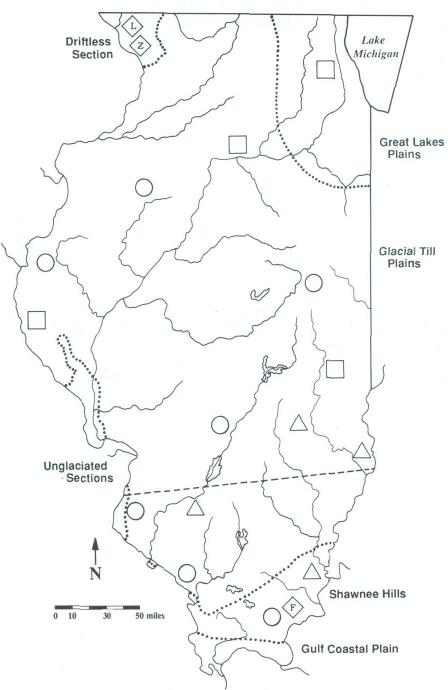
Fig. 1 PHYSICAL GEOGRAPHY MAP OF ILLINOIS
22
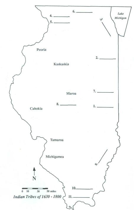
Fig. 2 CULTURAL GEOGRAPHY MAP OF ILLINOIS
Click Here to return to the Article
23
|