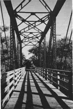
As park and recreation practitioners, we have all too often had fixations that land for recreation and park uses should be in neatly blocked areas with well defined boundaries. However, with the accelerated demand for lands and facilities to meet leisure time needs and the need to preserve more open space we must take a more comprehensive look at the jurisdictions within which we work. Whether we work at the community, county, regional or state level, we need to be more aware of the unusual opportunities, often in linear patterns, existing right under our noses. There continue to be great opportunities for park systems and communities to consider greenways and linear recreation ways as integral parts of their comprehensive plans and solutions to increasing development and preserving valuable open space. What are greenways? Greenways are linear parks or recreation ways which preserve ribbons of natural habitat or cultural features through urban areas or open countryside. Greenways typically follow a stream corridor or ridge line, an abandoned railroad right-of-way converted to recreational use, a canal, a scenic road or other route. In addition, there are many types of rights-of-way which can be explored for greenway uses, including power lines, canals, utility corridors, abandoned roads and railroads. These are examples of cultural or manmade linear opportunities, frequently having great historical significance. Nature also has given us some outstanding linear examples like rivers and streams, lake shorelines, valleys or geologic formations, such as ridge lines, escarpments, glacial moraines and other natural phenomena. Although the term "greenway" is relatively new, the concept of greenways goes back to before the turn of the century and reflects very positively on the planning of the early park systems. For example, Boston and Cleveland, both use the Illinois Parks & Recreation * May/June 1996 * 35 term "emerald necklace" to describe the greenways of parks and trails along their major rivers. Chicago, New York and Kansas City area park and forest preserve systems also used the concept of linear greenways along lake shores, river fronts and systems of parkways which were created to take people in their carriages or "motor cars" from one major park to another along shady, landscaped, linear extensions of the parks. These linear greenways frequently lend themselves to trail systems for hiking, hiking, cross-country skiing, snowmobiling, horse riding or canoeing. There are often opportunities for connecting major park areas with a linear greenway system or creating park nodes along the linear corridors. These linear corridors of open space bind man and nature. They serve as natural conservation areas and wildlife habitat and provide natural diversity to the landscape. They are green ribbons of open space available to all people for all levels of physical ability—young and old, urban and rural. The successful implementation of a regional greenway plan is dependent upon cooperation in the planning, acquisition and management of greenway corridors. In the past 20 years, northeastern Illinois has experienced tremendous urban sprawl. Urbanization has fragmented the countryside, severely jeopardizing the natural corridor systems that support biological diversity by providing the continuity that is necessary for the migration and propagation of plant and animal species. One example of an organized regional plan—the Northeastern Illinois Regional Greenways Plan—was developed in part because of the urban sprawl and concern about the fragmentation of the ecosystems. The vision of this greenway plan is to create a regional greenway network and provide a framework for coordinated greenway and trail preservation in northeastern Illinois. This 1,000-mile network will vary in scale from narrow ribbons of green in urban and suburban development to complex rural corridors a mile or more in width, incorporating diverse natural and cultural elements. They will represent a historic landscape such as the Chicago Boulevard system, incorporate traditional park-like settings and golf courses, cultural facilities such as the Chicago Botanic Garden and Brookfield Zoo, and preserve corridors of forests, wetlands, meadows and prairie. There is no perfect method for planning or building a greenway that will work in every community. Each area has its own specific needs, the land and resources have different constraints and the users, different requirements. However, some of the most innovative landscape design work associated with streams and wetlands has occurred through the detailed design of greenways within communities, counties or regions. These projects usually occur on public lands where jurisdictions are trying to achieve a high quality of resource management while also accommodating trail and other recreation uses. In some instances the greenways incorporate roadway facilities to create a scenic parkway, as referenced previously with some of the early park systems. While these greenways often contain areas that exist as—or are restored to—a natural condition, they tend to have a park-like quality and represent a compromise between a pristine riparian or wetland area and a developed park. These restoration projects can serve as models and examples to private land owners who develop landscapes that affect other streams and wetlands. Some communities have used almost all volunteer efforts in establishing a greenway plan or system. The most effective way is partnership among volunteers and local agencies cooperating in planning and establishing the system. Volunteers can often reach people who don't want much to do with "the government" and can obtain gifts of funds, easements or materials through unusual avenues. Agency personnel can provide maps, technical data and professional expertise to put into form the ideas of the volunteers in the community. As the loss of open space has become more apparent, particularly in urban areas, interest in all types of land conservation has risen to an unprecedented level. At the same time, the cost of land has continued to rise, but state and federal funds for land conservation has diminished. Protection of resource-based land has become more difficult. Greenways may be part of the solution to this problem because they often require less land than more traditional, non-linear parks, especially when recreation is a primary focus. Often conservation of land easements can be used to secure control of land at less cost than fee simple acquisition or that which can be obtained by gift. Complex ownership patterns bisecting potential greenways may hinder acquisition and increase costs; natural features may be aligned in a linear pattern but property boundaries rarely are. On the other hand, abandoned roads, railroads, and utility corridors tend to be comprised of single-owner parcels. Conservation of greenways, rivers and trails may result in reduced costs to local governments and other public agencies. By conserving a greenway corridor rather than permitting intensive development, local agencies may reduce costs for public services such as sewers, roads and school facilities. Establishing a greenway in an area prone to hazards such as flooding, may decrease costs for potential damages. Greenways and associated vegetation can also help control water, air and noise pollution by natural means, resulting in potential decreased pollution control costs. Potential greenways, such as a utility or abandoned railroad corridors, are often attractive to illegal use such as dumping. By promoting recreational use, these areas become self-patrolled and less prone to these problems. Although several years old, the 1987 report of the President's Commission on Americans Outdoors gave a strong boost to greenways by recommending that "communities establish greenways, corridors of private and public lands and waters, to provide people with access to open spaces close to where they live, and to link together the rural and urban spaces in the American landscape. "Greenways are a way to provide open recreation spaces for every American, close to home. Greenways are our vision of the future." The "future" of that report is now. Robert D. Espeseth is emeritus professor at the University of Illinois, Department of Leisure Studies, and Kathleen M. Cassens is the deputy director of the Joliet Park District. 36 * Illinois Parks & Recreation * May/June 1996 |
||||||||||||||||