 |
Home | Search | Browse | About IPO | Staff | Links |
|
Home | Search | Browse | About IPO | Staff | Links |
|
I • and • M
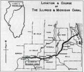
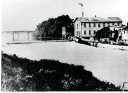
The Illinois and Michigan Canal, the first waterway to link the Great Lakes and the Mississippi River, opened in 1848, spurring the development of Chicago and the Upper Midwest in the nineteenth century. Before the railroads arrived, this tiny ditch, only six feet deep, transformed a frontier outpost into an industrial and commercial powerhouse. The dawn of the twentieth century witnessed the demise of the I and M Canal, but over time the canal was reborn, and it evolved into a new type of national park that has been copied worldwide. Chicago was a canal town in the first half of the nineteenth century, and the 60-foot wide, 96-mile long I and M Canal was the economic foundation of northern Illinois, bringing wheat to market from the plains and ferrying manufactured goods from the East.
The twentieth century began with the seeming death knell of the I and M Canal: the May 1900 opening of the Sanitary Canal between Chicago and Joliet, paralleling the first thirty-five miles of the old canal. While designed for sanitation rather than freight, by 1906 the new channel had siphoned most of the freight business from the smaller I and M. Soon, old wooden canal boats, 100 feet long by 17 feet wide, were sinking and rotting in their moorings at Lockport, site of Lock #1 and the original I and M Canal Commission Headquarters. Only the canal's southwestern stretch from Joliet to La Salle remained practical for shipping, and traffic continued to decline. During World War I in 1918, Joy Morton of Morton Salt lobbied the federal government to reinvest in the I and M Canal, which was still used to ship salt. Locks between Joliet and La Salle were upgraded, and the old I and M experienced a brief revival thanks to Morton's advocacy. But plans were afoot to channelize the Illinois River, creating a modern shipping route from Joliet to La Salle and making the rest of the I and M a historical relic.
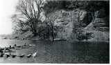
But the seeds of that relic's rebirth as a historical recreational resource were already apparent. Starved Rock, next to the I and M Canal, became Illinois' first recreational state park in 1911. Along the I and M's redundant northern stretch, small motorized pleasure boats with fringed and tassled canopies ferried weekend picknickers to amusement areas such as Joliet's Electric Park and Lockport's 31
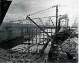
Dellwood Park. Thus, when the old canal south of Joliet was finally made obsolete by the completion of the Illinois Waterway Project in 1933, the canal and towpath were almost immediately converted into a recreational trail. The Illinois Waterway was a works project during the Great Depression, as was the Civilian Conservation Corps (CCC), which set up five camps along the I and M Canal. In these camps, young men worked on the improvement of the canal towpath as a trail and the construction of picnic shelters, culverts, bridges and even a lodge in adjacent parklands. These are visible today in all of the I and M Canal's five counties, from sites in the Cook County Forest Preserves to Starved Rock State Park where the CCC built the rustic Starved Rock Lodge. The I and M Canal's environment continued to develop as an industrial corridor despite the historic recreational trail along its spine. Petrochemical industries lined the new waterway through the first half of the twentieth century, joining the steel mills and grain elevators that had hugged the banks of the earlier waterways where the railroad tracks also ran. The southwest portion of Chicago along the Sanitary Canal became "Gasoline Alley," and tank farms and refineries lined the canal from Kedzie Avenue through Lemont, Lockport, and beyond Joliet. A massive TNT factory—the 22,000-acre Joliet Arsenal—was developed during World War II, and the Illinois Valley attracted its own industries, from the early nuclear power plant at Dresden (on the site of an I and M Canal mule barn) to chemical industries near Morris and the glass and sand industries of Ottawa. The I and M Canal towpath became part of the State of Illinois' parks and conservation system in the 1970s, just as the industrial might of the surrounding landscape began to wane with plant closings and job layoffs. The canal was a shadow of its former self. The I and M Canal had always relied on a system of feeder canals to maintain the water level in the eight-foot deep ditch, and after 1933, when sections of the canal began to dry up and silt in, only a fifteen-mile stretch from Channahon south of Joliet to Morris, and the final five miles between Utica and La Salle regularly had water. The last five miles of the I and M Canal was restored in the late 1970s, thanks to the La Salle Volunteers, who also reconstructed the wooden lock gates at Lock #14. This was the first of several volunteer efforts that inspired the I and M Canal National Heritage Corridor. The 1970s witnessed the rise of the historic preservation movement in the I and M Canal corridor, centered on public landmarks such as Joliet's Rialto Square Theater and Lockport's Central Square School, both saved from demolition about 1980. The growth of the environmental movement also benefited the old canal route. Openlands Project's 1979 DesPlaines River Valley initiative identified almost forty rare natural areas along the canal's northern stretch, and an effort was afoot to recognize the entire canal as an historical, natural, and recreational resource. The combination of environmental and historic preservation efforts led local boosters, businesses, and politicians to consider a heritage corridor that would promote the preservation of historic structures, the conservation of natural areas, and the development of recreational and tourism resources. In 1981 the National Park Service completed a concept plan for the I and M Canal National Heritage Corridor, combining features of recreational parks such as the Cuyahoga National Recreation Area and historic parks such as the former textile mills of downtown Lowell, Massachusetts, the first urban national park. Local corporations and businesses joined to form the Upper Illinois Valley Association (now Canal Corridor Association) to promote the creation of the I and M Canal National Heritage Corridor. 
The presence of businesses in the corridor concept was significant. Business leaders saw the corridor as a way to improve the local economy by capturing the new growth areas of tourism and recreation. The time was ripe, for the industrial corridor was rapidly losing its industry. In the late 1970s and early 1980s, plant closings and layoffs at oil refineries and steel plants had plunged unemployment in Joliet to 23 percent. The heritage corridor was a new kind of "partnership park" that involved no federal land ownership or regulation. The National Park Service would simply coordinate the efforts of private owners, state authorities, and local entities and provide an interpretive framework for sites as diverse as native prairies and wetlands, 1850s industrial warehouses, turn-of-the-century Main Streets, and reconstructed canal locks and aqueducts. The legislation was introduced by every member of the Illinois Congressional delegation in 1983 and signed into law by President Reagan in Chicago in 1984. The I and M Canal National Heritage Corridor unleashed a flurry of activity that 32
helped improve resources along the old canal over the next twenty years. National Park Service rangers coordinated the efforts of state, county, and local parks, forest preserves, historical societies, and private foundations. On the canal itself, numerous locks, aqueducts and the two remaining locktender's houses were stabilized and restored by the State of Illinois. The canal towpath trail was extended from 55 to 80 miles, and in the 1990s mile markers and new interpretive signs detailing centuries of canal history were installed. The Gaylord Building in Lockport, originally an 1838 canal warehouse, was restored as a National Historic Landmark, as was the 1874 Hegeler-Carus mansion in La Salle, two of the many private preservation projects in the canal corridor. Public projects included the restored Seneca grain elevator (a National Park Service endeavor) and restored prairies in Will, Cook, and Du Page counties. The nation's largest public art project created the "Watermarks" benches in 1998 at Chicago's Navy Pier, the eastern end of the I and M Canal corridor. Three benches composed of Venetian glass mosaic and ceramic tiles made by canal-area residents are set along a blue walkway symbolizing the inland waterway. Several projects have also introduced massive artworks into the I and M Canal corridor. In the mid-1980s, a former strip mine in La Salle County, adjacent to Buffalo Rock State Park, was reclaimed by artist Michael Heizer. Heizer designed five "Effigy Tumuli"— massive earth sculptures in the shape of native Illinois animals and recalling the Mound Builder culture that occupied the Upper Midwest during the last millennium. The figures, up to eighteen hundred feet in length and rising as much as twenty feet, represented a water strider, catfish, frog, turtle, and snake. Main Street programs were instituted in Ottawa, Lemont, and Lockport in the 1990s, leading to the preservation and restoration of numerous downtown commercial buildings. Main Street, a National Trust for Historic Preservation initiative, helps business and building owners in older downtowns capitalize on their unique architectural heritage through marketing, special events, and economic restructuring. The "partnership park" label was evident in projects like Joliet's Heritage Park, set atop the ruins of a nineteenth-century steel plant that had been demolished in the 1930s. This park, which included walking and biking trails, as well as Locks #3 and #4 from the Illinois and Michigan Canal, required the cooperation of state, county, and local governments. Similar partnerships, led by the Canal Corridor Association, are now working toward the re-creation of a working canal boat near Lock #14 in La Salle. The I and M Canal helped build a region, but the I and M Canal National Heritage Corridor is helping to build a world. By 1995, the heritage area concept had spread to over twenty federal sites in the United States alone, and to many more on a state or At the beginning of the twentieth century, the I and M Canal was dying, no longer a major force in the economy of the Upper Midwest. By 1933 it ceased to be a canal. By the end of the twentieth century, this non-functioning canal had become the centerpiece of a new post-industrial economy, inspiring countless efforts to conserve the region's rich natural resources and rehabilitate its landmark buildings for tourists and residents.
Overview Main Ideas Even though the I and M Canal is no longer in commercial operation, its legacy is a great one. It initiated a series of water transportation links that are still vital to the region's economy: the Sanitary and Ship Canal (1900) and the Illinois Waterway (1933). Rail, truck, and air transportation were added along the I and M route so that today many billions of dollars and goods flow through Illinois' transportation corridor. When the canal opened in 1848 it was a solution to the logistical problems of a young nation and a developing economy. This newly created transportation corridor generated a series of economic opportunities that can be seen in the subsequent growth of agriculture, manufacturing, and commerce in Illinois. In turn, this period of rapid urbanization and industrialization left such daunting problems as sewage and pollution while offering 33 new opportunities. By the first half of the twentieth century, three important trends were evident along the canal: recreation, conservation, and further industrialization. In the last fifty years new trends have appeared: a decline in manufacturing, extension of the Canal Trail for recreation, expansion of Goose Neck Prairie, the creation of the Illinois and Michigan Heritage Corridor, the emergence of huge transportation and distribution centers, and the renewed growth of Joliet. Globalization of the economy and environmental concerns are strong forces shaping both problems and opportunities along the I and M Canal route where the past and the future continue to be entwined. 
Connection with the Curriculum The I and M Canal is an important topic for teaching history on three levels—local, national, and global. It is also strong in providing opportunities to show the importance of geography in economic development and historical change. By studying the canal, students can see the trends in history at work: westward expansion, industrialization, and the growth of government to deal with new problems in a complex world. The lessons and activities may be appropriate for teaching Illinois Learning Standards 16.A.4a, 16.C.5a(US), b(US), and 16.C.5b(W) and also 17.C.4 a, b, & c. Teaching Level This lesson and activities are appropriate for grade levels 10-12. The topic is complex but accessible with teacher assistance at different ability levels. Objectives for Each Student
Materials for Each Student Handouts:
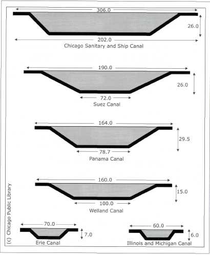
Poster paper or Internet access for extending the lesson Optional materials: A copy of the accompanying historical narrative—the visual "Cross Section of Notable Channels"—can be made into an overhead for projection or as a Power Point slide. Assessing the Lesson The individual lessons may be assessed according the instructor's standards and expectations (rubric). The instructor may also use the Social Science Rubric located at the Illinois State Board of Education site for Social Sciences.
Opening the Lesson Thinking About Opportunities, Problems, and Solutions: The history of the Illinois and Michigan Canal is one of human vision and effort in dealing with challenges. Over the 160-year history of the I and M Canal, a variety of opportunities, problems, and solutions have each played a role in motivating human activity in the area. What can we learn from the history of the Illinois and Michigan Canal? From ancient times canals have played a dramatic role in shaping and creating transportation corridors. These canals are familiar: the Grand, Erie, Suez, and Panama. The Illinois and Michigan Canal and its successor, the Sanitary and Ship Canal, are among the great canals in history. The great canals transformed regional and national economies, spurred commerce and industry, and altered international trade. By the twentieth century even more advances in transportation came in rapid succession: extension of railroads, air cargo, and interstate highways. The nation's transportation corridors also began to exhibit problems as a result of rapid growth: congestion, industrial and human pollution, 34 
loss of natural habitats, and even the shift of commerce to new modes of transport. With advances in transportation, some of the great canals are no longer the active commercial routes they once were. The Erie Canal has a new purpose of recreation and tourism, and it serves a historic reminder of the vision, government initiative, engineering, and labor that created each of these monumental works. Formerly the home of many manufacturers, northeast Illinois has seen a steady loss of plants and jobs since the 1970s. However, the transportation corridor created by the I and M Canal remains essential to the regional and national economy in the twenty-first century. Because of its importance as a rail, air, and truck hub, northeastern Illinois continues to be an efficient location for businesses to warehouse and distribute their goods. There has been immense growth in commerce along the old I and M Canal corridor in the last decade. In 2007 Joliet was one of the nation's fastest growing cities. The new and the old are intertwined in the Illinois and Michigan Canal National Heritage Corridor: new opportunities exist with e-commerce, problems are solved through multiple efforts; and plans are made for the twenty-first century. The accompanying narrative may be assigned to provide the background. For most students, a brief teacher introduction and completion of the Canal Quiz will serve as the warm-up for the essential question: What can we learn from the history of the I and M Canal? The first important point students will learn is that the I and M Canal and its successor, the Chicago Sanitary and Ship Canal, are among the great canals in history. The second focus in Activity 2 and 3 is that historical change is a cycle driven by opportunities and problems that generate solutions and new opportunities and problems. In the last 160 years the I and M Canal has been part of industrialization, a decline in manufacturing, and a growth in new transportation and cultural opportunities. Government has played a role responding to the larger economic and social issues in a number of ways that have changed with the times. Developing the Lesson In your discussions emphasize the importance of canals in our history. Emphasize what great feats of planning, engineering, and financing these canals were. Refer to the dimensions in the "Cross Section of Notable Channels" visual. As students are working with Activity 2—the list of events—encourage them to connect problems with solutions. The list of events can be examined many ways that will lead to important connections. Here are a few examples: Problem: Sewage from Chicago's rapid growth pollutes Lake Michigan and is corrected by the Solution: Sanitary and Ship Canal reverses the flow of the Chicago River. The creation of the Sanitary and Ship Canal widens the shipping lane and creates an opportunity to further expand marine transportation, but results in the end of commerce on the I and M Canal, a problem. Examples of opportunity include: westward expansion; industrialization creates new industries; and e-commerce, warehouse, and distribution centers expand. Encourage students to recognize cause and effect relationships, connect problems with solutions, and see how changing conditions create new opportunities. Concluding the Lesson Make sure students have connected local events with larger themes in American history. Activity 3 summarizes the historical cycle: westward expansion, transportation revolution, industrialization's benefits and problems, the Progressive movement, and the growth in government's role, Great Depression and the New Deal, the postwar and the cold war, the shift to post-industrial economy, reform movements for the environment and preservation, and, finally, the Internet revolution and shifts in national and global commerce. Extending the Lesson To extend or bring closure to Activity 3, students could develop a flow chart: Learn more about the Illinois and Michigan National Heritage Corridor by visiting the website www.canalcor.org/. Click on "About" and have students analyze the mission statement: Canal Corridor Association is a 501 (c) 3 non-profit organization dedicated to preserving history, protecting nature and open space, and creating tourism destinations in the I & M Canal National Heritage Corridor. What problems is the mission statement addressing? Create posters from topics in the lesson: (1) Visual timeline of the transportation history of northeast Illinois (2) Flow chart of the cycle of opportunities, problems, solutions, new opportunities, new problems, and new solutions. 35 Field Trip Possibilities include:
Assessing the Lesson The teacher may assign an essay for students to write based on their class activities. The posters would also be a good assessment of student learning. Student Activity 1: Canal Quotient CQ Quiz. Distribute and discuss. Correct answers are 1) Erie 2) Illinois and Michigan 3) Suez 4) Sanitary & Ship 5) Panama 6) Sanitary and Ship 7) I and M 8) Panama 9) I and M 10) Erie and I and M 11) Sanitary and Ship 12) Erie -New York I and M -Chicago 13) Panama, Suez, and Sanitary & Ship 14) Erie and I and M 15) Sanitary and Ship Student Activity 2: Illinois and Michigan Canal over the Years and Glossary. Working with the glossary and list of events involves students in examining the important changes in the canal area over time. Students may work together in pairs or small groups examining the list of events and using the glossary to identify unfamiliar items and estimate a time period. Students should categorize each item as a problem, opportunity, or solution. Instruct students to write the century on the worksheet next as nineteenth, twentieth or twenty-first, and mark the event P, 0, or S. Ask the students to try to connect problems with solutions on the list. The list of events can be examined many ways that will lead to important connections. Student Activity 3: Illinois and Michigan Canal over the Years Organizer Sheet. Either in small groups or as a class, discuss the events by identifying the opportunities, problems, and solutions while transferring them to the organizer sheet. Examine the solutions. How effective were the actions taken at solving the problem or realizing the opportunity? Identify the role of private businesses and state and national government in responding to opportunities and problems in the Illinois and Michigan Canal area. Connect local events with larger themes in American history: westward expansion, transportation revolution, industrialization its benefits and problems, the Progressive movement and the growth in government's role, Great Depression and the New Deal, the postwar and cold war, suburban sprawl, the shift to post-industrial economy, reform movements for the environment and preservation, and finally shifts in national and global commerce. To extend or bring closure to Activity 3, students could develop a flow chart or create posters from topics in this lesson: Bibliography: Chicago Public Library, Down the Drain, the Big Ditch www.chipublib.org/digital/sewers/history4.html Sara Sage and Linda Torp, Problems as Possibilities, Problem-Based Learning for K— 16 Education, Association for Supervision and Curriculum Development(ASCD), 2nd ed. Alexandria, VA, 2002.  36 Activity 1 What's Your Canal Quotient? Your CQ? Refer to these famous canals for your answers:
B. Illinois and Michigan Canal (connects Illinois River to Lake Michigan) C. Panama Canal (connects Atlantic and Pacific Oceans) D. Sanitary and Ship Canal (reverses the flow of Chicago River into Des Plaines River) E. Suez Canal (connects the Red Sea to the Mediterranean Sea) 
When were these canals built? Arrange the canals in chronological order from earliest to latest: 6) Which canal has the widest waterway? 7) The narrowest waterway? 8) Which canal is the deepest? 9) The shallowest? 10) Which two canals used mules to pull special barges carrying people and products? 11) Which was the only canal that did not create, but only improved, a new trade route? 12) Which two canals were directly responsible for the growth of the two largest American cities? 13) Which three canals remain important commercial shipping routes today? 14) Today, which two canals are part of major conservation, historic preservation, and recreational efforts? 15) Today, which active canal is closest to the physical center of the world's most important economy?
No matter what your CQ, you are about to learn more about the Illinois and Michigan Canal and the transportation corridor it created. Canals are frequently an underappreciated part of Illinois history. 37 Activity 1 – Continued
38 Activity 2 – The Illinois and Michigan Canal over the Years Using the glossary and general knowledge think about these important events and decide whether an event is an opportunity, problem, or solution. Also indicate the century: nineteenth, twentieth or twenty-first. 
39 Activity 2 – Continued Glossary:
40 Activity 2 – Continued
41 Activity 2 – Continued
42
43 Activity 3 Seeing the Big Picture: The Illinois and Michigan Canal over the Years 
Nineteenth Century Opportunities:___________________________________________________________________________________________ Problems:______________________________________________________________________________________________ Solutions:______________________________________________________________________________________________ 
Twentieth Century Opportunities:___________________________________________________________________________________________ Problems:______________________________________________________________________________________________ Solutions:______________________________________________________________________________________________ 44 Activity 3 
Twenty-first Century Opportunities:___________________________________________________________________________________________ Problems:______________________________________________________________________________________________ Solutions:______________________________________________________________________________________________ 45 |
|||||||||||||||||||||||||||||||||||||||||||||||||||||||||||||||||||||||||||||||||||||||||||||||||||||||||||||
|
|
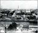
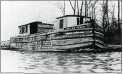
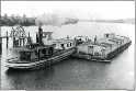
 Stone, coal, salt, sugar, wheat, corn, whiskey, and livestock were shipped on the little channel. Mules towed canal boats through fifteen locks between Bridgeport and La Salle/Peru, Illinois. When construction began in 1836, Chicago was a frontier town with less than three thousand inhabitants. By the time the canal opened in 1848, Chicago had twenty thousand residents, and other towns along the canal route were growing rapidly, including Joliet, Ottawa, Lockport, Lemont, Morris, La Salle, and Peru. The canal was profitable even after railroads followed its corridor in the 1850s. By the 1870s steam-powered canal boats became the rule. A "deep cut" dredging of the canal bed in 1871 helped in the effort to tackle Chicago's water pollution problems, but not enough. By 1892 work began on the
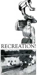
 regional level. By the dawn of the new millennium, the concept was being tested as far away as China, where the Weishan Heritage Valley in Yunnan province has a similar strategy of combining preservation, natural area conservation, tourism and economic development in the world's fastest growing economy.